


Horseshoe Bend Arizona
In the fable of The Tortoise and the Hare, Aesop cautioned us to temper our “need for speed,” because “slow and steady wins the race.” In the case of the Horseshoe Bend Overlook, slow and steady doesn’t necessarily win any race, but taking a gradual, more mindful approach to this now-iconic symbol of the American Southwest will give the viewer a better appreciation for the true complexity of the area’s geology. And that, in our book, is definitely one for the “win” column!
As you exit your vehicle in the newly-expanded Horseshoe Bend parking area just South of Page, Arizona, your first challenge is to make your way up a mildly steep incline through deep, sometimes unwieldy sand. Though most visitors succumb to the temptation to make quick work out of this small obstacle, you might view it as an opportunity to take a trip through a real-life “Jurassic World.”
About 200 million years ago, a massive sea of sand dunes covered the landscape from Arizona to Wyoming. Known to geologists as “ergs,” they eventually became petrified (turned to stone) by water and minerals, solidifying into a uniform layer of sandstone over 2,000’ thick in some areas. After the bedrock of Navajo Sandstone formed, other sedimentary layers of sandstone, mudstone, calcite and limestone settled on top of it, then began to wear away under the constant scouring of relentless winds, flash floods, and extreme heat and cold. Today, the Navajo sandstone is once again exposed, and its top layer turning to sand. So this hill that makes you go “erg” is what remains of a gigantic sand dune that actually saw dinosaurs walk upon it. Indeed, there is a small, but hard-to-find dinosaur track about 50 yards from the end of the trail. Tell us the GPS coordinates if you happen to find it!
As you crest the hill, the trail begins to undulate and you’ll notice the tone of the landscape has taken on more jagged, sloping characteristics. Whitish gravel and chunks of sand also make an appearance. These are remnants of the calcite, or limestone layer that was once here. The diagonal stripes in the rock formations tell the story of how the sand dunes were petrified, yet retained their former shape as minerals, rain and snow changed their molecular composition over the course of 20 million years.
As you get closer to Horseshoe Bend Overlook, you’ll notice that some of the rock formations sport dark, sandy nodules. These are known as “iron concretions.” Because it was heavier than sandstone, iron tended to cluster up into small spheres during the process of petrification. As the sandstone erodes away, these concretions are becoming exposed to the elements once again. Occasionally, they will break away from the sandstone bedrock. When they do, they become what are known as “Moki Marbles.” If you find one – or more – please don’t pocket them. Remember, take only pictures and leave only footprints!
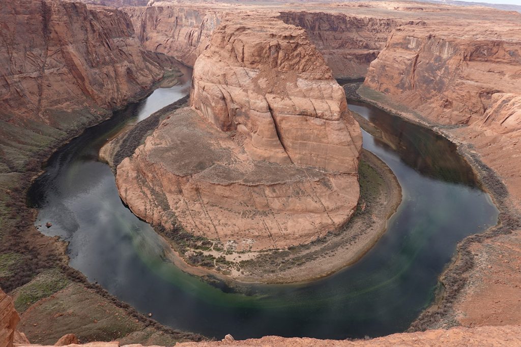
If all this sounds pretty amazing so far, wait until you see what’s ahead of you: the very thing you came here for – Horseshoe Bend! A geologic masterpiece sculpted by the Colorado River, Horseshoe Bend is an example of what happens when water takes the path of least resistance. Approximately 5 million years ago – or what a geologist might describe as “just the other day” – the Colorado Plateau abruptly uplifted. The rivers that flowed across this ancient landscape were suddenly trapped in their beds. Seeking a new natural level, with the help of gravity, the Colorado River began cutting through rock layers deep and fast. Here at Horseshoe Bend, an unstoppable force met an immovable object, namely, a sandstone escarpment. Since this rock formation wasn’t going to budge anytime soon, the river did the most logical thing it could: it went around it. The result is the 270° bend in the river (called an “incised” or “entrenched meander”) you see before you. Who knows, in a few million years, the stubborn promontory might finally decide to give way to the river’s whims, and future tourists could be viewing an attraction that bears a resemblance to Rainbow Bridge!
At this viewpoint, you can see the waters of the Colorado River in all their sparkling, blue-green glory as they drift along toward the Grand Canyon.”
But, that’s in the realm of sheer speculation for now. What’s in the realm of absolute certainty is that this is one of the most intimate views of the Colorado River you’re likely to experience on your Northern Arizona vacation. At this viewpoint, you can see the waters of the Colorado River in all their sparkling, blue-green glory as they drift along toward the Grand Canyon. Where else can you take a selfie with this timeless, majestic waterway in the background? Certainly not at the Grand Canyon – from the South Rim, there is only a handful of viewpoints that the Colorado River can be seen from, and then only a small stretch before it disappears again behind a butte or plateau. So pause for a few minutes to breathe in the fresh air and appreciate this magnificent view for how powerful and miraculous it truly is!